Impressions from a Lost World: The Discovery of Dinosaur Footprints
Glacier and Lake
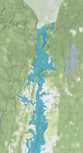
No large-scale, accurate maps exist of the extent of all of the glacial lakes in southern New England, so our mapper, Joe Kopera had to take several factors into account when creating the glacier and Lake Hitchcock maps. He chose four periods in the evolution of the lake that give snapshots of where the glacier and lake were in relation to places on this website, such as the Holyoke Range and Turners Falls, Massachusetts.
Glacial Lake Hitchcock was continuously forming from meltwater at the toe of a massive ice sheet. The weight of the ice pushed the earth's crust down into the mantle by several hundred feet, and it takes many centuries for the crust to "bounce" back. When the lake was at its deepest, the ice sheet still covered the the valley north of the Connecticut-Massachusetts border (the middle two maps here). By the time the ice sheet had melted back to about Turners Falls, the land in southern Connecticut had been free of ice for 2,000-3,000 years and was rising.
In order to make an accurate map of the lake's extent at the various times, Joe had to "depress" the current-day landscape by several hundred feet in GIS to match its elevation shortly after the ice sheet left the area, as determined by precisely measured elevations of lake sediments and ocean high-stand deposits that were correlated with radio-carbon dating. He then filled the valley with water up to the paleo-elevations of the lake, as determined by deposits in different areas. The extent of the lake at these times closely matches the sediment deposits.