Impressions from a Lost World: The Discovery of Dinosaur Footprints
The Parallel Roads of Glen Roy
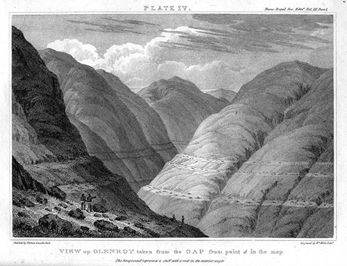
It is easy to see why the parallel terraces were mistaken for roads on these treeless mountains. Image courtesy of Wikimedia Commons.
In Gaelic legend, the so-called Parallel Roads of Glen Roy are the hunting roads of Fingal (or Finn Gall), enemy of Ireland's Finn MacCool, who, according to legend, made the Giant's Causeway. A strategic location for protecting the western Highlands, it is thought that Picts built a fortress on this site during the 7th century, and another castle was built there in a fight for the crown of Scotland in the 13th century. The castle was used again in religious factional fighting during the 17th century. Whether in legend or history, it was believed that the horizontal roads had been built by human hands—or a giant's hands—not through natural processes.
In 1817, a Scottish geologist named John MacCulloch realized that the three narrow "roads" were actually terraces remaining from ancient beaches. However, because the "roads" did not completely enclose a basin, MacCulloch could not explain how the lake had been held in and why whatever barrier was no longer in evidence. Any force strong enough to burst one end of the former lake would need to be strong enough to destroy the whole area. How could a lake calmly drain away, leaving a gap at one end and clear, undisturbed terraces on the remaining sides? One possibility was that even though they were now far inland, the beaches had been on a sea rather than a lake, created in a time when the ocean was much higher and encroached further inland. In that case, however, why were there no fossil shells or other evidence of marine life?
Charles Darwin studied the region in 1838, and despite the lack of marine material, decided that sea beaches had to be the correct answer, partly because this solved the question of how the landscape was left intact when the water drained out. His paper, published the next year by the Royal Society, helped to gain him the right to put the coveted F.R.S. (Fellow of the Royal Society) after his name.
Darwin's ideas were soon eclipsed. In 1840, Louis Agassiz and William Buckland visited Glen Roy together and found what they deemed evidence of former glaciers: striations in large rocks, erratic boulders, and scattered debris. Agassiz theorized that the “parallel roads” were indeed former lake (not sea) shores; the barrier—a glacier—had melted away. This notion fit with Agassiz's new theory that enormous glaciers had once covered significant parts of the globe. However, the theory did not gain broad acceptance for many years, so the question of Glen Roy remained unanswered.
Today, geologists believe that Glen Roy is the remnant of a lake formed during a glacial period 11,000-10,000 years ago. The valley bottom is made up of lake deposits and the "roads" show sequential advances of the glacier pushing the level of the lake up to 850 feet, 1,066 feet, and nearly 1,150 feet above sea level, as evidenced by the terraces.
During WWII, Britain suffered a shortage of timber that convinced the government to reforest many parts of the country after the war, including Glen Roy. The Nature Conservancy negotiated with the government to plant forests only in designated areas, in order to preserve the integrity of this valuable geological site, which can still be visited today.